Marine Charting & Cartography
-
 C-MAP®Reveal X Coastal US West Coast and Baja microSD Format Bathymetric Electronic Chart (M-NA-T-206-R-MS)Reveal X Coastal US West Coast and Baja microSD Format Bathymetric Electronic Chart by C-MAP®. A Fresh, Dynamic Navigation Experience. Always have the latest chart data at your fingertips with the C-MAP X range. With dynamic...Next-Generation Charts: Fresh new chart presentation, with full-featured vector data and rich featuresHigh-Res Bathymetry: The best C-MAP® bathy data, with all-new, intuitive Map Inspector tool$269.99
 - C-MAP®Reveal X Hawaii, Marshall Islands and French Polynesia microSD Format Electronic Chart (M-NA-T-210-R-MS)Reveal X Hawaii, Marshall Islands and French Polynesia microSD Format Electronic Chart by C-MAP®. A Fresh, Dynamic Navigation Experience. Always have the latest chart data at your fingertips with the C-MAP X range. With dynamic...Next-Generation Charts: Fresh new chart presentation, with full-featured vector data and rich featuresHigh-Res Bathymetry: The best C-MAP® bathy data, with all-new, intuitive Map Inspector tool$269.99
- C-MAP®Reveal X Nova Scotia to Chesapeake Bay microSD Format Electronic Chart (M-NA-T-202-R-MS)Reveal X Nova Scotia to Chesapeake Bay microSD Format Electronic Chart by C-MAP®. A Fresh, Dynamic Navigation Experience. Always have the latest chart data at your fingertips with the C-MAP X range. With dynamic presentation ensuring a...Next-Generation Charts: Fresh new chart presentation, with full-featured vector data and rich featuresHigh-Res Bathymetry: The best C-MAP® bathy data, with all-new, intuitive Map Inspector tool$269.99
- C-MAP®Reveal X US North/Central Lakes microSD Format Electronic Chart (M-NA-T-212-R-MS)Reveal X US North/Central Lakes microSD Format Electronic Chart by C-MAP®. A Fresh, Dynamic Navigation Experience. Always have the latest chart data at your fingertips with the C-MAP X range. With dynamic presentation ensuring a clear,...Next-Generation Charts: Fresh new chart presentation, with full-featured vector data and rich featuresHigh-Res Bathymetry: The best C-MAP® bathy data, with all-new, intuitive Map Inspector tool$183.59
- C-MAP®Reveal X US North/East Lakes microSD Format Electronic Chart (M-NA-T-213-R-MS)Reveal X US North/East Lakes microSD Format Electronic Chart by C-MAP®. A Fresh, Dynamic Navigation Experience. Always have the latest chart data at your fingertips with the C-MAP X range. With dynamic presentation ensuring a clear,...Next-Generation Charts: Fresh new chart presentation, with full-featured vector data and rich featuresHigh-Res Bathymetry: The best C-MAP® bathy data, with all-new, intuitive Map Inspector tool$183.59
- C-MAP®Reveal X US North/West Lakes microSD Format Electronic Chart (M-NA-T-211-R-MS)Reveal X US North/West Lakes microSD Format Electronic Chart by C-MAP®. A Fresh, Dynamic Navigation Experience. Always have the latest chart data at your fingertips with the C-MAP X range. With dynamic presentation ensuring a clear,...Next-Generation Charts: Fresh new chart presentation, with full-featured vector data and rich featuresHigh-Res Bathymetry: The best C-MAP® bathy data, with all-new, intuitive Map Inspector tool$183.59
- C-MAP®Reveal X US South/Central Lakes microSD Format Electronic Chart (M-NA-T-215-R-MS)Reveal X US South/Central Lakes microSD Format Electronic Chart by C-MAP®. A Fresh, Dynamic Navigation Experience. Always have the latest chart data at your fingertips with the C-MAP X range. With dynamic presentation ensuring a clear,...Next-Generation Charts: Fresh new chart presentation, with full-featured vector data and rich featuresHigh-Res Bathymetry: The best C-MAP® bathy data, with all-new, intuitive Map Inspector tool$183.59
- C-MAP®Reveal X the Great Lakes microSD Format Electronic Chart (M-NA-T-201-R-MS)Reveal X the Great Lakes microSD Format Electronic Chart by C-MAP®. A Fresh, Dynamic Navigation Experience. Always have the latest chart data at your fingertips with the C-MAP X range. With dynamic presentation ensuring a clear,...Next-Generation Charts: Fresh new chart presentation, with full-featured vector data and rich featuresHigh-Res Bathymetry: The best C-MAP® bathy data, with all-new, intuitive Map Inspector tool$269.99
- Maptech®WPB New Jersey Coast. Raritan Bay to Cape May V3 Chart Kit (WPB0360-03)WPB New Jersey Coast. Raritan Bay to Cape May V3 Chart Kit by Maptech®. 3-rd Edition. New York Harbor to Cape May, NJ. Easy-to-use format includes GPS waypoints, pre-plotted courses and more than 380 marinas. 24 chart pages.Expertly crafted from premium materialsDesigned to match rigorous quality standards$69.64
- Navionics®HotMaps Platinum Lake Maps West microSD Format Electronic Chart (SD/HMPT-W6)HotMaps Platinum Lake Maps West microSD Format Electronic Chart by Navionics®. The most comprehensive lake charts! Advanced features help you quickly target the best spots and catch mone fish! Check out the detailed Naulical Chart plus...Lake ChartsOne foot contours$240.89
- Navionics®Navionics+ Canada & Alaska microSD Format Electronic Chart (010-C1367-30)Navionics+ Canada & Alaska microSD Format Electronic Chart by Navionics®. Detailed coverage of the Atlantic and Pacific coasts, inland lakes and waterways of Alaska and Canada (except YT and NU). Coverage includes the Aleutian Islands,...Marine and lake chartsOne foot contours$165.42
- Navionics®Navionics+ Chile, Argentina & Easter Island microSD Format Electronic Chart (MSD/NAV+5XG)Navionics+ Chile, Argentina & Easter Island microSD Format Electronic Chart by Navionics®. All-in-one max detailed cartography for marine and lakes makes Navionics+ the perfect choice for cruising, fishing and sailing. Get the most...Follow detailed routes that are generated for you, from a real start point to a real end point, even through narrow channels where they’re needed most!Create 1 ft/0.5 m HD bathymetry maps of your favorite areas in real time!$180.30
- Navionics®Navionics+ Mexico and Central America microSD Format Electronic Chart (MSD/NAV+4XG)Navionics+ Mexico and Central America microSD Format Electronic Chart by Navionics®. Head out with confidence! All the same marine and lakes content and advanced features found in Navionics+ are augmented with 3D View, satellite overlay...The most advanced technology and best imaging available in multi-dimensional chartsImproved 3D view with enchanced bottom contour profiles and high-resolution photo overlay$230.41
- Navionics®Platinum+ Boston and New York microSD Format Electronic Chart (SD/674P+)Platinum+ Boston and New York microSD Format Electronic Chart by Navionics®. Head out with confidence! All the same marine and lakes content and advanced features found in Navionics+ are augmented with 3D View, satellite overlay and...The most advanced technology and best imaging available in multi-dimensional chartsImproved 3D view with enchanced bottom contour profiles and high-resolution photo overlay$243.94
- Navionics®Platinum+ Canada & Alaska microSD Format Electronic Chart (010-C1367-40)Platinum+ Canada & Alaska microSD Format Electronic Chart by Navionics®. Detailed coverage of the Atlantic and Pacific coasts, inland lakes and waterways of Alaska and Canada (except YT and NU). Coverage includes the Aleutian Islands,...The most advanced technology and best imaging available in multi-dimensional chartsImproved 3D view with enchanced bottom contour profiles and high-resolution photo overlay$292.39
- Navionics®Platinum+ East Gulf of Mexico microSD Format Electronic Chart (SD/630P+)Platinum+ East Gulf of Mexico microSD Format Electronic Chart by Navionics®. Head out with confidence! All the same marine and lakes content and advanced features found in Navionics+ are augmented with 3D View, satellite overlay and...The most advanced technology and best imaging available in multi-dimensional chartsImproved 3D view with enchanced bottom contour profiles and high-resolution photo overlay$241.05
- Navionics®Platinum+ Maine microSD Format Electronic Chart (SD/673P+)Platinum+ Maine microSD Format Electronic Chart by Navionics®. Head out with confidence! All the same marine and lakes content and advanced features found in Navionics+ are augmented with 3D View, satellite overlay and panoramic photos...The most advanced technology and best imaging available in multi-dimensional chartsImproved 3D view with enchanced bottom contour profiles and high-resolution photo overlay$246.91
- Navionics®Platinum+ South and Central Florida microSD Format Electronic Chart (SD/632P+)Platinum+ South and Central Florida microSD Format Electronic Chart by Navionics®. Head out with confidence! All the same marine and lakes content and advanced features found in Navionics+ are augmented with 3D View, satellite overlay...The most advanced technology and best imaging available in multi-dimensional chartsImproved 3D view with enchanced bottom contour profiles and high-resolution photo overlay$241.05

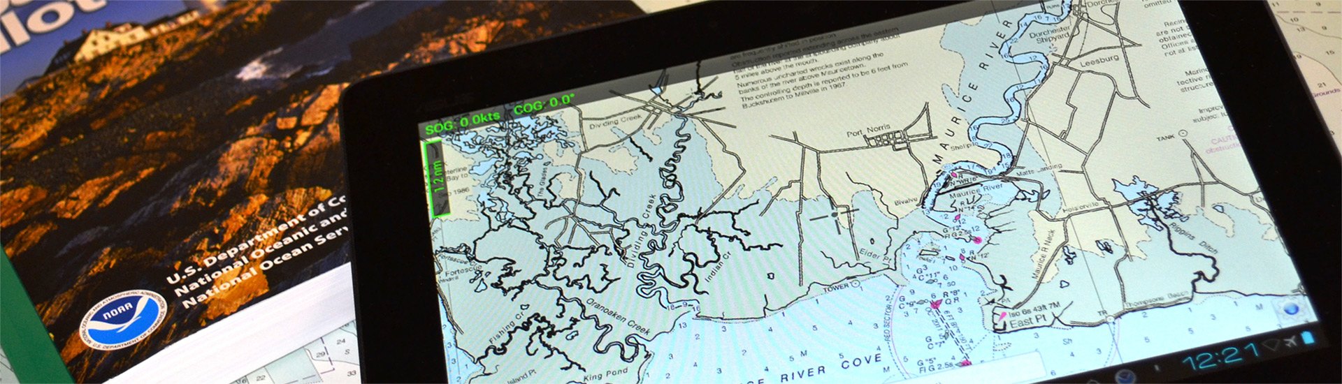
A safe boating experience cannot be imagined without nautical maps. Though conventional paper marine maps are still used on every boat, new technologically-advanced electronic charts have made the entire map reading and course planning routine much easier. So what is electronic cartography? The definition is pretty straightforward - electronic charts are digital versions of the most dependable government-issued paper charts and maps crated to simplify your navigation.
The data that is used by electronic charts comes from a number of government sources including NOAA, Canadian Hydrographics, and many others. Electronic charts give mariners greater possibilities on the water, providing you with innovative object-oriented cartography. Normally the electronic charts are displayed on chartplotters, multifunction displays (smartphones) or personal computers. Chartplotters, that are typically waterproof, are usually opted for when you own smaller 40’-50’ boats, while tablets and smartphones are well-suited for larger sail and power boats. PCs are usually used on large vessels and commercial boats.
Electronic charts are available in a number of formats: dynamic raster scanned charts (Maptech) that are basically direct video images of paper charts. They are precise and reliable versions of conventional paper charts. Vector charts (Garmin, Navionics, C-Map) typically take less memory as they have the information transformed into coordinates in a data file. Vector charts are “object oriented”, so when a cursor is positioned over icons, numerals, words or other features, additional windows with detailed descriptions will pop up. New generation 3D maps with high-definition relief will provide you with improved underwater view.
Electronic charts for chartplotters are usually available on small microSD memory cards that can be inserted into a GPS unit. In their turn, smartphone and PC charts are downloadable. While the paper maps show signs of heavy use, over time signaling you to get a newer version, the electronic chart will look brand new, but may pose danger when outdated. Thus, your electronic maps should be regularly updated and kept current to provide greater level of protection against marine hazards. Either used for recreational and commercial boating or fishing, interactive electronic charts will help you make the most of your boating experience.